Urban Sea Systems
Watershed, urban region, and adjacent sea form one system. Ports, cables, shipping lanes, and data centers make these regions the nodes of global trade and communication, and hot spots of pollution and risk.
Workshop · Seattle · December 2026
The Salish Sea is one coupled system of watersheds, cities, ports, and coastal ocean, shared by two nations. This working meeting brings together the people who model, observe, and govern it to design the first modules of a digital twin, and to decide what it would take to build one.
Starts in 0 days 0 h 0 min
Why this workshop
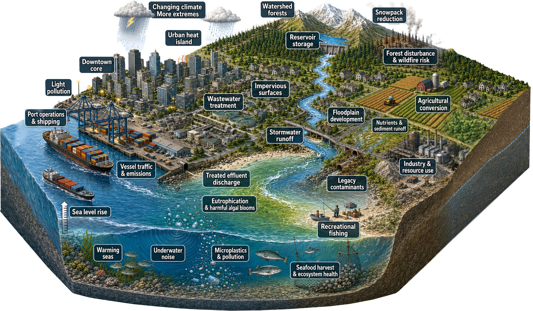
Urban Sea Systems run from mountain headwaters through rivers, estuaries, and port cities to the coastal ocean. More than two hundred of them line the world's coasts. They hold a large share of the human population, organize much of the global economy, and are governed in pieces that do not match the scales on which water, sediment, organisms, goods, and information actually move.
Watershed, urban region, and adjacent sea form one system. Ports, cables, shipping lanes, and data centers make these regions the nodes of global trade and communication, and hot spots of pollution and risk.
Currents, rivers, and storms ignore borders. Land use, fisheries, water quality, transport, and emergency management are each managed well in isolation, and rarely together. Cumulative and cascading risks fall through the gaps.
Shared, continuously updated representations of system conditions let existing institutions see linkages they could not see before, test what-if questions, and coordinate without waiting for governance to be redesigned.
A digital twin, in the sense used here, is not one model or one dashboard. It is a persistent, continuously updated set of domain models, each owned by the experts who already run it, coupled to live observations and to each other, with interfaces that decision-makers can use. The Salish Sea has five decades of observation, modeling, and institutional investment behind it. The workshop asks whether that foundation can be federated into a working prototype, and what a first build would require.
What complex adaptive means
Three ideas, taken in sequence, define the instrument the workshop sets out to build. Each one imposes a design obligation.
Mechanism · John Holland
When many agents interact under local rules, system-level behavior emerges from the couplings and cannot be deduced from the parts.
Couple many domain modules rather than perfect any one. The couplings are the object.
Limit · Simon Levin
Ecosystems are the foremost complex adaptive systems, and their emergent behavior includes outcomes that no model will predict.
Characterize the range of plausible outcomes and let decision-makers rehearse against them. Explore, do not forecast.
Remedy · Elinor Ostrom
Communities can govern shared resources durably through their own evolving rules. The decision-makers belong inside the system.
The parties who must act on the system take part in the instrument that represents it. A module, not a user.
The prototype
The Salish Sea is a large, complex mountain-to-seafloor basin shared by the United States and Canada: the Strait of Juan de Fuca, the Strait of Georgia, and Puget Sound, fed by the Fraser and nine other major rivers, with Vancouver, Victoria, Seattle, Tacoma, and Olympia on its shores. Few coastal regions are as well observed or as densely modeled. Few are governed by as many jurisdictions. That combination makes it the right place to build a first Urban Sea digital twin, and to learn how the pattern could travel to systems at other stages of development.
Think big, start small
A digital twin of an Urban Sea System is not one model. It is a federation of domain modules, each owned by the experts who already run it, coupled through well-defined exchanges of state, flux, and boundary conditions. The workshop starts with six modules where regional models and committed people already exist, and treats the couplings among them as the real work.
with biogeochemistry
Currents, temperature, salinity, oxygen, carbonate chemistry, and plankton across the estuary, from the Strait of Juan de Fuca to Puget Sound and the Strait of Georgia.
Three complementary operational models, one of which already supplies daily boundary conditions to another across the border.
forcing from the atmosphere
Regional weather ensembles, atmospheric rivers, and downscaled climate projections that drive flooding, runoff, and stormwater design.
land to sea
Forest hydrology, land cover, streamflow, and stormwater from the Fraser, Skagit, Snohomish, and Puget lowland basins into the sea.
The pieces exist across agencies. The workshop must choose the first watershed representation the twin adopts.
nutrients, toxics, microplastics, airsheds
Fate and transport of nutrients, toxics, oil, and microplastics in water, and the thinner strand of airshed modeling for the region.
Water pollution is well covered through module 1. Air pollution needs a named owner.
the human engine
Vessel traffic, rail and truck flows, terminal operations, and their resilience to disruption, on both sides of the border.
Vancouver is already building a port digital twin. The US side needs integration work.
earthquakes, tsunamis, floods, spills
Cascadia megathrust and crustal-fault scenarios, tsunami inundation, coastal flooding, and the human-generated hazards of spills and infrastructure failure.
The human-generated half has no single owner yet. The workshop will decide how much of it the first twin attempts.
Four layers
The six modules are peers. Beneath them sit two foundations. Above them sits the coupling fabric that turns a set of models into one adaptive system.
Cross-domain flows of water, heat, sediment, nutrients, organisms, decisions, and schedules that bind modules into one system. The hardest and most novel work.
Six expert-owned models that turn live flow into understanding, each with its own maturity and its own community.
Marine sensing (cabled observatories, moorings, radar, ferry boxes, ships) and civic telemetry (water, sewage, power, traffic, air). A model with no live flow is a study. A model coupled to observation is a twin.
Maps, bathymetry, shorelines, fixed geography, and the historical record. The quiet substrate the system stands on.
Program
Three days move from a shared vision, to a buildable first set of modules and their couplings, to the practical path forward.
Draft program. Times and sessions will change as the agenda is developed with participants.
What Urban Sea Systems are, why they matter, what digital twins can and cannot do, and a first critique of the candidate modules.
The coupled watershed, urban, and marine system. The two hundred systems along the world's coasts. The governance mismatch, and what better stewardship could look like.
An accessible account of digital twins across domains, what evolving AI adds, and what an active user community makes possible. Technical, scientific, and societal facets, plus data flow, management, and interoperability.
Domain experts tell us what is missing, what is miscued, and what should divide or combine. The goal is a module set the room can own.
Shaped with Indigenous partners.
Turn the refined modules and their couplings into something buildable, with owners, data readiness, and a scoped first build.
Each module identifies who owns it, what already runs, and what a first contribution to the twin would be.
Structured capture of the state, fluxes, and boundary conditions each module needs and provides, and of data readiness at each interface.
Marine sensing, civic telemetry, and the geospatial baseline that every module draws on. What an integration substrate has to provide.
The mismatches to bridge, the resources required, who benefits, who decides, and the commitments that leave the room.
Jurisdictional, national, cultural, economic, and resilience gaps, and how a shared representation could help bridge them.
The practical steps toward a first build. Where the twin lives, who pays, and how data from many communities can be shared with confidence.
Which communities gain from what-if questions, and how results earn trust across boundaries.
Participate
About fifty people: the modelers, observers, port and utility operators, tribal and First Nation partners, agency staff, and technologists who already work on some part of the Salish system. Participation is by invitation. If you think you should be there, tell us why.
Circulation, weather and climate, watersheds, water and air quality, hazards.
Cabled observatories, moorings, radar, ferries, civic telemetry, regional data portals.
Ports, utilities, emergency managers, state, provincial, federal, tribal, and First Nation agencies.
Geospatial platforms, cloud infrastructure, data interoperability, AI and assimilation.
No. It is a working meeting of about fifty invited participants. Outputs will be published on this site.
The meeting is designed for in-person work. Remote participation will be considered for specific sessions.
Use the button above, or write to the contact in the footer, with a few lines on the part of the Salish system you work on.
Details on costs and travel support will be included with invitations.
Yes. A roadmap and a concept paper are planned outputs. Both will be posted here.
Logistics
Meeting room to be announced with invitations.
Seattle, WA 98195, USA
Campus mapSeattle–Tacoma International Airport (SEA). Link light rail runs from the airport to the U District station in about 50 minutes, and the campus is a short walk from there.
Amtrak Cascades trains and intercity buses connect Vancouver, BC to Seattle in three to four hours. A passenger ferry links Victoria's Inner Harbour to the Seattle waterfront.
Hotel options near campus will be shared with invitations.
Conveners
The workshop is convened by ocean scientists and the organizations that observe the Salish Sea, with an organizing committee drawn from the University of Washington and partners on both sides of the border.
Convener
Professor Emeritus, School of Oceanography
University of Washington
Oceanographer and lead architect of the Regional Cabled Array, the interactive ocean observatory off the Pacific Northwest coast. Co-author of the Urban Sea Systems concept.
Convener
Marine geologist, Center for Habitat Studies
Moss Landing Marine Laboratories, San José State University
Marine geologist and seafloor habitat mapper. Co-author, with John Delaney, of the 2025 characterization of Urban Sea Systems.
Co-convener
President and Chief Executive Officer
Ocean Networks Canada
Leads Ocean Networks Canada, which operates the cabled ocean observatories off British Columbia, including arrays in the Strait of Georgia and Saanich Inlet.

Organizing committee
Associate Professor, Earth and Space Sciences
University of Washington
Seismologist working on data-driven monitoring of geohazards and on digital twins of weather-compounded hazards. Leads the GAIA HazLab.
Support
The workshop is convened by the University of Washington and Ocean Networks Canada, with advice and support from partners on both sides of the border.
Partner list in progress. Organizations appear here once their support is confirmed.
Resources
Start here to arrive with a shared vocabulary.
Defines Urban Sea Systems and characterizes three North American examples: the Salish Sea, Chesapeake Bay, and the south shore of Oahu.
The argument behind the workshop. Copies will be shared with participants.
Names a Healthy Urban Sea as one of the cross-cutting themes for U.S. contributions to the UN Decade of Ocean Science for Sustainable Development.
The international effort to build digital twins of the open ocean, the complement to the coastal and urban problem addressed here.
Collective benefit, authority to control, responsibility, and ethics. The framework the workshop follows for Indigenous data.
An Urban Sea System today. Watersheds, cities, ports, and coastal waters form one dynamically coupled system, from headwaters to the offshore.
J.R. Delaney, H.G. Greene and M.R. Delaney
More than two hundred Urban Sea Systems line the world's coasts and form the nodes of a global trade network.
J.R. Delaney and H.G. Greene, after Greene and Delaney (2025)
The dual-layer structure of global trade. Shipping routes at the surface and submarine cables on the seafloor converge at the ports of Urban Sea Systems.
J.R. Delaney, H.G. Greene and M.R. Delaney
The Salish Sea and its watershed, shared by the United States and Canada. The upper Fraser basin more than doubles the conventionally drawn watershed.
J.R. Delaney, H.G. Greene and M.R. Delaney
Six starting modules of a complex adaptive digital twin for an Urban Sea System. Each is a domain model owned by experts and coupled to the others.
J.R. Delaney
Layered architecture for the Salish Urban Sea digital twin. Baseline and observing layer beneath, domain modules above, and the seams that couple them.
J.R. Delaney
A digital twin as enabling infrastructure. Interconnected modules, one dynamic system, and outcomes for the people who use it.
J.R. Delaney
Three North American Urban Sea Systems: the Salish Sea, San Francisco Bay, and Chesapeake Bay.
J.R. Delaney and H.G. Greene
The same coast as a natural refuge, before it became a port-centered region. What will it look like in thirty years?
J.R. Delaney, H.G. Greene and M.R. Delaney
A continuous, adaptive cycle. Observations feed the twin, models and simulations generate insights, and insights inform the decisions and interventions that reshape the real world.
J.R. Delaney, H.G. Greene and M.R. Delaney
From theory to design obligations. Holland's mechanism, Levin's limit, and Ostrom's remedy each require a feature of the instrument: federated, bounded rather than predictive, and governed from within.
J.R. Delaney, H.G. Greene and M.R. Delaney
Real world, twin, and governance. The real world informs the twin, governance reshapes what is modeled and how, and interventions act on the system.
J.R. Delaney, H.G. Greene and M.R. Delaney